“Every beautiful spot in Baja is at the end of a terrible road.” I’d read this in a blog post that now I can’t find to give credit. However, from our many experiments while there, we found this statement to be absolutely true.
Our goal for the day was to see El Cañon de los Zorros (Fox Canyon) and the aguas calientes (hot springs). They were more or less in the same area according to other blog posts, near the town of Santiago which was about twenty minutes south of Los Barriles. For once I had good directions, or so I thought, so we weren’t too worried about the fact that we’d gotten off to our normal late start.
We soon found out that the directions made absolutely no sense. We went down a dirt, washboard road for a few miles and then turned around thinking it couldn’t be right. After we’d turned around, we passed a minivan. They slowed and asked if we’d come from the Canyon. We explained that we were looking for it, too.
“We’ve been driving around for two hours,” said the driver. “We’ve tried every other road in town. This has to be the one.”
We weren’t convinced so we took the one good piece of advice from the directions. “If you can’t find it, ask someone in town.” Yep, it was back out that terrible road.

To be completely honest, I didn’t think the road was that bad. It was solid washboards, long, dusty, and narrow (almost impossible for two cars to pass). But, other than the narrowness, it wasn’t too different from the gravel roads in Nebraska. We only had to use the 4WD once and that was because we’d missed a turn. It seemed never-ending, though, probably because we were never sure we were heading in the right direction.
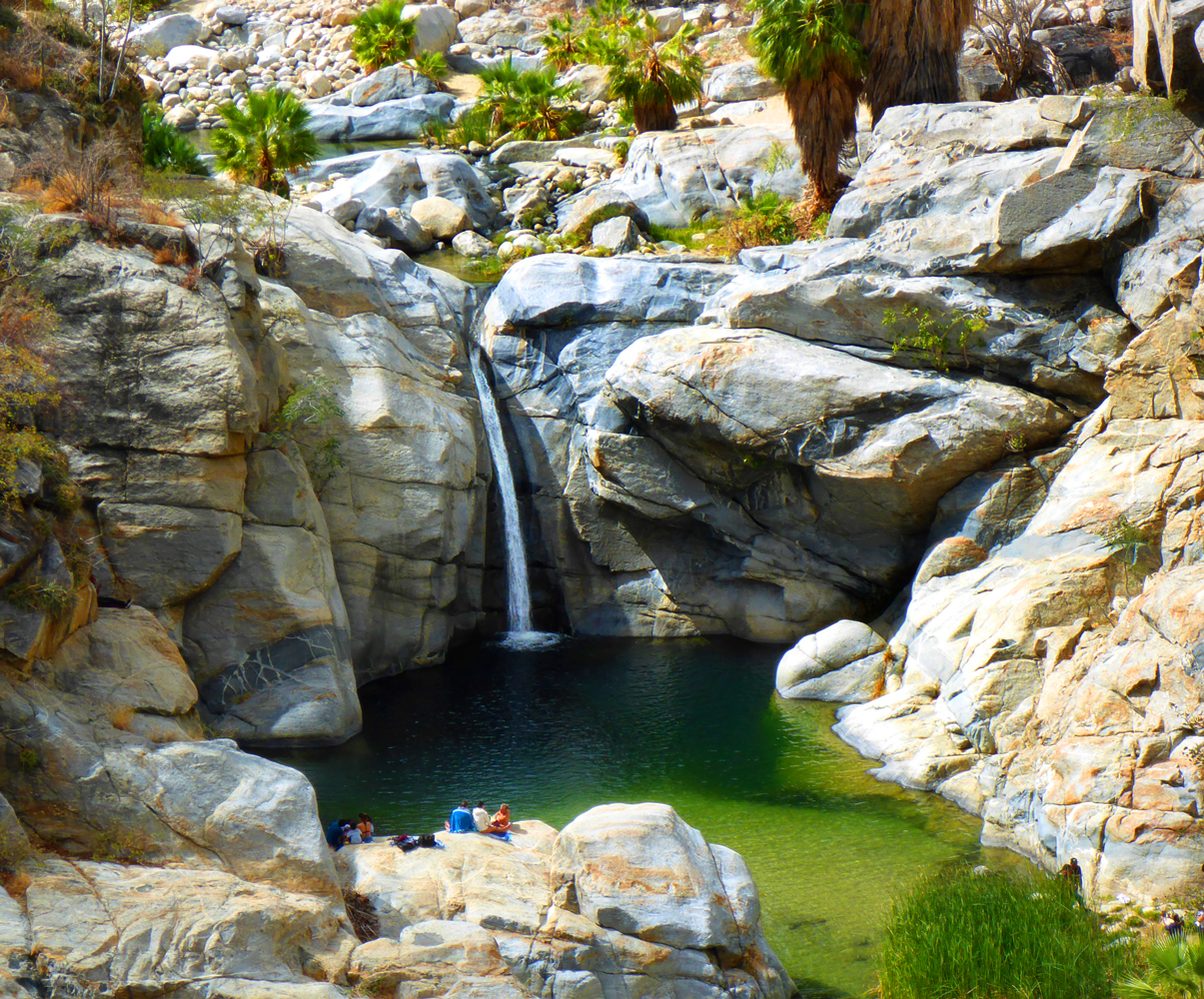
This is my piece of advice for anyone going to Cañon de los Zorros: It is in El Rancho Ecologico Sol de Mayo. There were plenty of signs for El Rancho Ecologico Sol de Mayo. But we assumed two things: #1 – surely the directions would have mentioned the fact that the canyon/waterfall was inside of El Rancho; and #2, surely the signs for El Rancho would mention something about the canyon/waterfall if they owned it. Well, you know what they say about assuming (and don’t call me Shirley).
Finally, we arrived. We got there right behind the minivan we’d seen earlier. We put Brandi on her leash and went to the little hut to pay our entrance fee where the man told us, “Sorry, no dogs.” Ugh. It was too hot to leave her in the car so we took turns hiking to the waterfall.
It was only about a 10 minute hike. And the second I saw it I knew immediately that the long, dusty drive, the no dogs rule, the entrance fee (I can’t remember what it was but I think it was higher than I thought it would be), was all totally worth it. A 30 foot waterfall, sheer rock walls, a palm-tree lined pool – in the middle of the desert. Indescribable. I hope Mitch’s video conveys what words can’t.
I traded with Mitch. One of the Ranch’s dogs followed him all the way to the waterfall. I guess it didn’t understand the no dogs rule. Hmmm…
 By the time we left it was too late to make it to the hot springs. We’d get an earlier start the next day.
I really wanted to check out the Parque Nacional Cabo Pulmo on the East Cape area. It is an underwater park known for incredible snorkeling and diving. Also, I had read some blog posts that talked about the great, free camping opportunities on the beach there. We were leaving Los Barriles in two days but didn’t have another campground lined up. And there were supposed to be a couple of surf breaks that Mitch wanted to check out.
We turned off the main highway and drove through the town of La Ribera all on great roads. We continued going south. The road was newly paved, very smooth, easy driving. But we knew it was going to change. And about 5 miles beyond La Ribera, it changed with a vengeance. Dirt, washboards, sharp rocks, dips, potholes (can you call them potholes if there wasn’t any pavement to begin with?). I think it was less than 20 miles on this road but it took us over an hour to get to Cabo Pulmo.
Maybe it was because the sky clouded over, maybe it was because it was very windy, maybe it was because, every 50 yards or so, menacing, red lettered “Private Property” signs hung on barbed-wire fences – but, I have to admit, it wasn’t our favorite area in Baja. Don’t get me wrong, the water views were still amazingly beautiful. But we just didn’t get the fun welcoming vibe that we’d gotten everywhere else.

We came across the first camping area that we’d read about. I don’t know the official name of it but we christened it “Basura Beach” (basura means trash). We drove through the entrance gate thinking we’d find someone in the campground to ask about the policies since there were so many private property signs. But it was eerily quiet. We drove past abandoned 5th wheels and truck campers, past a camper that had made its home in the ruins of house, past a camper that was part bread truck part lean-to cardboard shanty. Any open site had piles of trash in it. And the beach was completely covered in rocks. We weren’t feeling the love.
This campground was only about a mile from the tourist town of Cabo Pulmo. There must be a time of year when this place is wall-to-wall people because it had as many snorkel shops as Key West. It was way too windy for any hope of snorkeling, though, so we kept going.
There was supposed to be another campground, called Playa Arbolitos, about 5 km beyond Cabo Pulmo. At about that distance we saw a sign on the turn off to a side road advertising a beach for kayaking, paddleboarding, and snorkeling with the hours of operation. But just beyond the sign was a gate with the name of a development and the private property signs again. The gate was open but we figured it was, as the sign said, private. So we kept going.
We drove for about another 5 km and found another camping area. It matched the description of the southernmost camping area we’d read about – in a wash, fishing shanties on one side of it, a well. It, too, was surrounded by barbed wire with the private property signs. But, unlike the stangely quiet Basura Beach, there was plenty of activity here. We pulled in and, thinking there might be someone you were supposed to register with since there were fifty million private property signs, asked a guy outside his Winnebago how you went about camping here.
He looked at us like we were aliens and then, with much effort, said, “Find a spot. Camp” and with that he turned and walked away.
Okey dokey.

It was a really beautiful spot. A headland, a cove, sapphire-blue water. Had we driven our camper, we would have camped there. But it wasn’t spectacular enough to make us want to haul our camper over 25 miles of that god-forsaken road.
On our way back, we decided to take a chance and pull into the beach at the private property gate. The road curved around and down, past a small farm, and ended in at a trailer surrounded by stacks of kayaks and paddleboards. In the wash, just a little further, we saw a VW camper backed up against the hillside. The attendant confirmed that camping was allowed and let us check it out without paying. Our truck camper would have fit, but just barely. The beach was pretty and, had it been calm, it would have probably been a great snorkeling/kayaking/paddleboarding spot. But the camping area was claustrophobic and again, we’d have to return on that road. So we headed back north without finding camping or surfing.
Because of that god-forsaken road, it’d taken us much longer than we’d planned. But we decided we’d try to get to the hot springs too, if only for a couple of minutes. We drove through Santiago and headed south, as we’d been told. “Once you get out of town, just follow the power lines,” were the directions. By now, you know how the story goes.
We got there, finally. Terrible roads, multiple power lines, pausing at turns – “Which way do you think?”, stopping for directions. We only had about 15 minutes before we needed to start heading back. We parked over looking the hot springs area. We saw that a small stream had been dammed with a low cement wall which formed a pool above and below. We quickly changed into our suits and headed down the trail where we saw a woman shaving her legs in the lowest pool. Mitch, the germophobe, paused, said he needed to repark the Jeep, and turned back.


I continued on around the dam to the pool above. It was cool, no, cold. But there were about four people resting against the rocky cliff on the far side of the stream where someone had stacked up rocks forming a separate pool. It turned out that the hot water (and it was really, really hot) came right out of two little holes in the cliff face. They made room for me and as soon as I sat down, hundreds of tiny little fish surrounded me and started nibbling my skin. Weeiird. I’m told a lot of people absolutely love the feel of it. I guess I’m just not crazy about being eaten alive though. Mitch did finally make it back and sat with his swim trunks legs held tightly around his thighs, trying very hard to relax.
This, sadly, was our last adventure in Los Barriles. It was time to move on, with or without exactly knowing our next destination. There are some places on this earth that might not be instant, all-encompassing love at first site, but where, in a short time, you feel so comfortable that you know that you’ll be back.