“Mitch is going to freak out,” I said out loud to myself as I peered up through the windshield at the low-hanging branches. I was in the Jeep leading Mitch, in our new (to us) 12-foot-2-inch tall, 28 foot long class A RV, to our campsite in the Bonita Canyon Campground in the Chiricahua National Monument.
Oak and pine trees crowded the narrow, one-way road as it twisted and turned. “He’s not going to be happy,” I said again.
Then I saw the dip in the road through the dry wash. A quick, steep down and quick, steep up, the white concrete scarred with dark scrapes and gashes where previous RVers had left remnants of their rigs. “Oh god.” I didn’t look in the rearview mirror to see his expression.
I’d checked though, I’d read the reviews. We were supposed to fit in here. Eventually we did shoehorn ourselves into our site, inching this way, then readjusting and inching that way. We sacrificed only a bit of paint from our tow bar to the concrete dip.
But getting into our site was not our biggest frustration with this campground.
We knew this would be dry camping (no water or electric hook-ups). No big deal because the campground had fresh water and a dump station. Or so the description said.
We’d been on the road for a few days prior to this. Our fresh water tank was empty and our black water (yes, the nasty stuff) was full. We’d planned to take care of both issues right before settling into our site for our five-day stay.
Driving in though, I couldn’t find the dump station. I spotted the camp host and asked her.
“There’s no dump station here,” she said. “The closest is Wilcox, 37 miles away.”
We’d just come from Wilcox. Not only was it 37 miles away, it was 37 miles downhill. And another 37 miles uphill to get back. On a pancake-flat road with a tail wind, we get 7 mpg. We decided to go into strict conservation mode.
Then the water. They had plenty of spigots. But none of them had hose attachments. There was no way to fill our tank. We didn’t have a funnel, so we hacked apart an empty gallon jug, fashioned it into a funnel, and spent the first evening hauling water from the spigot to our manual fresh water tank fill, most of it spilling down the side of our RV.
I’d been looking forward to this camping spot since I’d made the reservation over a month earlier. A remote location, no cell service—I craved the forced disconnection. Now, we’d have to cut our stay short. We decided to cram what we could into two days.
Located in southeastern Arizona, Chiricahua National Monument is a “sky island” named after the mountains it protects (the word “chiricahua” is a Native American term for a wild turkey). Arizona has several sky islands—isolated mountain ranges where the elevation is high enough to change the vegetation and animal life, yet small enough that the different species interact.
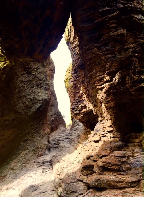
But the really cool thing about Chiricahua is its rock formations. The Chiricahua Apache called them “standing up rocks” which is the best description. They form spires and pinnacles and, when you allow your imagination license, ducks, kissing couples, mushrooms, a woman with a bun, organ pipes, etc. In an area called the Echo Canyon Grotto you can crawl around in endless dark, cool chambers reminiscent of a Harry Potter adventure.
I did the short hike around Massai Point and then up Sugarloaf Mountain to see the old weather station at the top. At 7310 feet, the view was amazing. But the most fascinating thing was the port-o-potty just a short distance from the weather station. It wasn’t a long or arduous trail. Still, I couldn’t imagine how they got it up there. And more mysterious yet, how do they clean it??


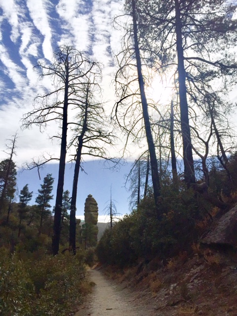
I did a longer hike the next day, about 7.5 miles out and back, to see the Heart of Rocks Loop. Heart of Rocks is an area with a high concentration of fantastical rock formations—ones with names such as Punch and Judy, Duck on a Rock, and Old Maid. The entire hike was beautiful but the loop section was especially spectacular because of the scenery of course, but also because of the trail itself—climbing up and down narrow steps carved into rock, the feeling of being amongst these ancient beings—and the fact that there wasn’t a scenic drive to get there. You had to walk at least 3 miles in and 3 miles back out. For over half of my hike, I saw only three other people.


Mitch’s favorite part of the park was the scenic Bonita Canyon Drive, which led from the Visitor’s Center to Massai Point, gaining 1,470 feet in eight miles. What goes up must come down, and he wanted to see how fast he could bike down that road. (When I drove the Jeep down from Massai point, I never touched the gas but I had to brake a few times.)
He made it to the top on his second try. Here’s his excellent video of his trip down along with a tour of the campground:
If you are tent camping or in a smallish RV, I highly recommend this park. Although I’ve found the Arizona landscape to be a constant surprise, this national monument is even more so. For high clearance RVs larger than 26 feet, well, don’t say I didn’t warn you!

6 replies on “Chiricahua – Frustrating, Gorgeous”
Very cool. Do you have a drone?
We do! (Well, Mitch does. I don’t have the patience to learn how to work it!) So that was me driving the RV on the way to the park entrance so that he could do the drone shot.
We appreciated your review. We had looked at this camp ground as a potential destination, but will need to rethink how we want to visit the park. Thanks!
I’m glad it helped! I think I read on your blog that you have a truck camper? You should be good in the campground with a truck camper although you still might catch a few branches. This park is definitely worth a visit though!
We recently got a 26 ft trailer so we are learning to check the length restrictions.
That’s a good habit to get into. Good luck!