
Years ago, when I’d first heard about the proposed route of the Millsboro by-pass, it broke my heart. They could have built it over ag land. Instead, they bulldozed the route through an undeveloped, natural area of Millsboro Pond—one of my favorite places to paddle.
Mill ponds are sprinkled all over Delaware and Maryland. Basically, damming any creek or drainage creates a potential paddling spot. But what makes one pond better than the other? What makes a person want to return time and again versus simply checking it off a been-there-done-that list?
I’m sure the answer is different for everyone. Scenery and the chance to spot wildlife are important pieces of the puzzle. Access and an easy launch play a part. But for me, there has to be an element of exploration. No matter how many times I’ve been there, I’m still wondering what’s around that next bend. It has to surprise me.
Millsboro Pond checks all those boxes.
Back in the mid-90s, when Mitch convinced me to move to Delaware, Millsboro Pond was the second place he took me paddling (the first was Trussum Pond). When we owned Coastal Kayak, we offered tours of Millsboro Pond, guiding paddlers up the pristine Cow Bridge Branch. I’ve paddled the pond for sunsets and full moons. I’ve been there for all seasons. But I hadn’t paddled there since they started constructing the by-pass. I just couldn’t make myself do it.
They finished the by-pass this past summer and, with pomp and circumstance and local politicians and dignitaries, opened it to traffic in mid-September. Almost two months later, on a beautiful November day, Mitch and I decided to see if there was anything left of the Millsboro Pond we’d loved.
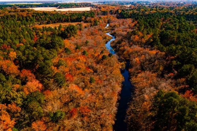
I always think of Millsboro Pond as having three prongs. The western prong leads to the spillway at Betts Pond. At one point, you could paddle to the base of a railroad bridge near the spillway. But the last time I tried, it’d become too overgrown. The middle prong closes in quickly without a discernible route through. But the eastern prong, oh, the eastern prong—it is called Cow Bridge Branch, and it transports you to a different world.
After launching, we paddled, as usual, along the eastern shoreline past a couple of well-cared-for waterfront homes with lots of windows. Just past the houses, the dreaded bridge came into view. Metal and concrete, clean and free of graffiti for the time being, soared overhead. Rocks and sprayed-on grass covered the earth graded to create the ramp to the bridge. All of it new, and hard, and shiny—completely unnatural and completely incongruous to the surroundings.
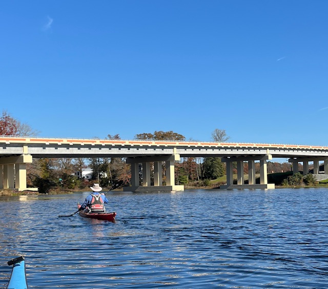
Paddling under a bridge, any bridge, always gives me a strange feeling—awe and unease. Maybe it’s the combination of the thundering traffic above me, not trusting the speeding drivers, and not entirely trusting the construction either, while I’m traveling below, unnoticed, on a different medium at a different pace in a different world.
Once we got past the bridge, though, just like that, it was gone. What I mean is, because, thankfully, they placed the bridge at the very end of Cow Bridge Branch, right where it widens into Millsboro Pond, once you’re beyond it, the natural state of the creek takes over and erases the awful concrete and metal and rocks from your mind.
Cow Bridge Branch starts at Morris Mill Pond on Zoar Road and travels about four miles before emptying into Millsboro Pond. Four miles doesn’t seem very far. Eight miles round trip should be a nice, manageable full-day paddle. But once you get a mile or so upstream, deadfalls make progress slow-going. And the current is noticeable. This day, we turned around about two miles in, the furthest I’d been. In the past, Mitch has almost made it all the way to Zoar Road.
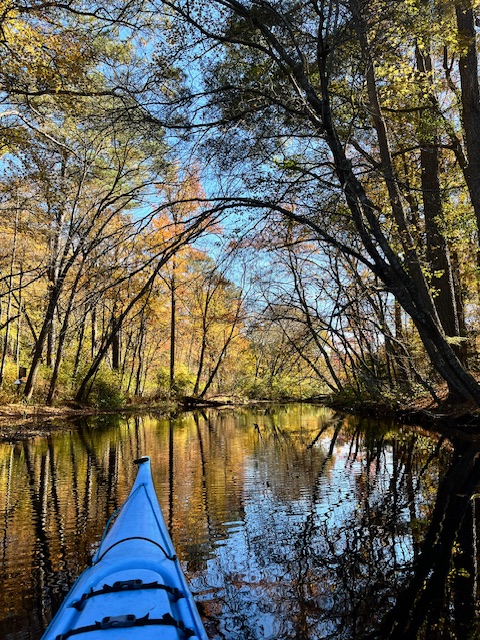
The stream twists and turns through a mostly deciduous forest. In places, the clear water tumbles over a bottom of sand and gravel, although along the banks is the soft, sandal-sucking mud composed of decades of undisturbed plant detritus. Beaver lodges dot the banks, especially in the wider, slower downstream water, and many young trees in this area bear the telltale sign of beavers—a ring of bark chewed off around the base. We’ve occasionally been fortunate enough to see otters swimming along the banks, although not this day. We did see a Bald eagle, Blue herons, and many Northern red-bellied cooters sunning themselves on logs.
The wildness of Cow Bridge Branch is not by happenstance. It’s not that it’s just been lucky enough to escape the buzz saw of developers. The Doe Bridge Nature Preserve, designated in 1991, cradles most of the western side of the stream and both sides in some places. (You’ll know the land that’s not part of the preserve because of the hunting blinds and the “No Trespassing” signs.) The preserve protects fifteen rare, threatened, or endangered plant, animal, and insect species, (one of which, the Chermock’s mulberry wing butterfly, is found in only one other place in the world) as well as historical remnants of a colonial settlement. And since there is no public land access to the preserve, the only way to experience it is by water.
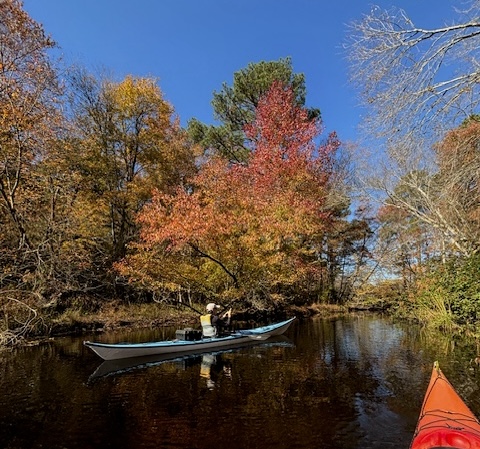
On this beautiful fall day, only two months after the road opened, we found the paddling experience at Millsboro Pond and Cow Bridge Branch to still be spectacular. However, there is no way a busy by-pass won’t have a negative effect on the flora and fauna of the area. The bridge scuppers will allow run-off, including oil, grease, heavy metals, and de-icing chemicals, to fall directly into the pond. There will be animal strikes as vehicles speed along the highway. We were there on a weekday in November—the off-season. Imagine a steamy Saturday in July or August. The road noise and fumes will be significant.
For human and corporate stakeholders, this was probably the best route for the bypass. But it certainly wasn’t the best route to protect this special place. It’s unfortunate that wildlife and nature don’t have bank accounts. They have to rely on us, a terribly unreliable species, to fight for them.
My advice: Get out to Millsboro Pond sooner rather than later. This spring, once the water warms, do yourself a favor and experience this special place.
Map of route:
https://www.mapmyride.com/workout/8699688833
This is a link to my Map My Ride route. I forgot to start it at the launch so the mileage isn’t accurate.
If you go:
Google map: https://maps.app.goo.gl/7XTvmKuGBbwwLgDLA
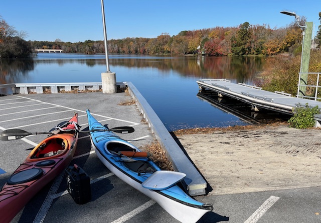
Access: This is a DNREC Division of Fish & Wildlife property. There is no fee to use the ramp or to park. Parking is limited. And, most importantly, there are no restrooms! You’ll want to be prepared.
Conditions: The wooded shoreline means the pond is blocked from most wind directions. It is not tidal. Sometimes during the summer, the algae can be thick in the main part of the pond. But I’ve never experienced thick algae in Cow Bridge Branch.
Hungry? These days there are so many restaurant options in Millsboro. My favorite is Nectar. I was sad to see Blue Water Grill leave, but happy that another great restaurant replaced it.
Info for this post came from:
Delaware Online Story: ‘No other option’: How Millsboro bypass will affect rare, threatened, endangered species
